Hundreds of flood warnings remain in place across England
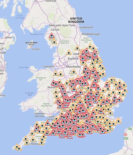
While the worst of the rain has passed, the Environment Agency still has more than 300 flood warnings in place across England.
There are also more than 330 flood alerts.
Flood warnings are for areas where flooding is expected. Flood alerts are for areas where flooding is possible but less likely.
There are also 13 flood warnings in place for Wales.
You can check for warnings and alerts near you on the Environment Agency website.
Key events
Nottinghamshire County Council declared a major incident on Thursday due to rising levels along the River Trent and several residents of Radcliffe Residential Park, an estate of static caravans for the over-55s just to the east of the city, were evacuated.
Caroline Douglass, the Environment Agency’s flood director, said the Trent was at “some of the highest levels we’ve seen in 24 years”.
She told BBC Breakfast more than 1,000 properties had been flooded across England this week, with that figure likely to increase.
Douglass added: “We have had very wide rainfall.
Over November and December, following Storm Babet and Storm Ciaran, the ground was incredibly saturated right across the country, particularly in the east. But also that’s just been topped up over the pre-Christmas period. That rainfall from this week has just added to that, so there’s really nowhere for the water to go. The ground is completely saturated so in that situation we get more flooding and greater impacts than we’ve seen and probably in areas where people aren’t used to.”
Here are the latest images coming across the wires:
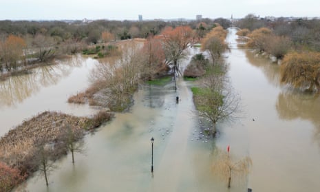
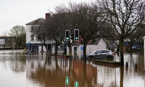
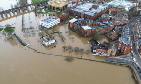
The highest rainfall totals recorded on Thursday were 35.2mm at Otterbourne in Hampshire, with a wide range of 20-30mm across much of the southern counties of England.
The Environment Agency said the impact of surface water and river flooding would continue to be “significant” across parts of England over the next five days.
Train companies have also been affected by the deluge, with Great Western Railway warning that several lines remain closed due to flooding, including between Swindon and Bristol Parkway, Reading and Castle Cary, and Liskeard and Looe in Cornwall.
A landslip at Arlesey in Bedfordshire was also affecting Thameslink services.
Hundreds of flood warnings remain in place across England
While the worst of the rain has passed, the Environment Agency still has more than 300 flood warnings in place across England.
There are also more than 330 flood alerts.
Flood warnings are for areas where flooding is expected. Flood alerts are for areas where flooding is possible but less likely.
There are also 13 flood warnings in place for Wales.
You can check for warnings and alerts near you on the Environment Agency website.

Seventy firefighters called in to help with Hackney flooding
Ten fire engines and around 700 firefighters were called to flooding in Hackney, east London, overnight after a canal burst its banks.
The London Fire Brigade says 10 acres of properties were affected.
Around 50 people were led to safety.
Station commander Dan Capon, who was at the scene, said:
Firefighters worked through the night to ensure the scene was safe and evacuated a number of people from surrounding buildings.
We urged people to avoid the area where possible. Remember – if your property is affected by flooding, move to a higher level where possible.
Significant impact of flooding possible across England today – Environment Agency
The Environment Agency has said “significant surface water and river flooding impacts” could continue today.
The EA’s Stefan Laeger said:
Significant surface water and river flooding impacts are possible across parts of the Midlands and the south and east of England on Thursday and Friday due to heavy localised rainfall falling on already very saturated catchments.
Ongoing minor impacts are also likely across much of England over the next five days as some larger rivers slowly respond to recent and forecast rain.
Showers will continue on Friday morning, according to forecasters, and are likely to affect parts of south-west and eastern England, Wales and areas in Scotland.
Storm Henk leaves flooded homes and roads across England

Steven Morris
Heavy flooding continued across parts of England on Thursday as a major incident was declared in Nottinghamshire and communities in Gloucestershire were left almost totally surrounded by water.
With the wind and heavy rain of Storm Henk expected to continue sweeping across the UK through the night, people were forced out of their homes in Shrewsbury, while parts of Worcester city centre were under water and emergency planners warned people in at-risk areas along the River Trent to make preparations in case they needed to evacuate. Tewkesbury in Gloucestershire was almost completely surrounded by flood water, with several roads cut off and authorities telling people who need to evacuate to make their way to a dedicated rest centre.
On Thursday evening there were still more than 550 flood warnings and alerts in place for England and Wales. The Environment Agency said about 450 properties had been flooded this week.
Stefan Laeger, a flood duty manager at the agency, said: “Significant surface water and river flooding impacts are possible across parts of the Midlands and the south and east of England on Thursday and Friday due to heavy localised rainfall falling on already very saturated catchments.
“Ongoing minor impacts are also likely across much of England over the next five days as some larger rivers slowly respond to recent and forecast rain.”

